
When Clarence Darrow squared off against William Jennings Bryan in the Scopes trial in Dayton, Tenn. 85 years ago, both attorneys likely drank water from Richland Creek. The town's water supply once flowed out of a reservoir just below the confluence with Laurel Creek. The one-foot-diameter pipe still runs along the creek, broken in places and no longer connected to the small dam.
Running through a narrow gorge it has carved into the eastern escarpment of the Cumberland Plateau, Richland Creek now provides recreation to Dayton residents and visitors. Boulders define the creekbed, creating deep swimming holes and fast-flowing chutes that attract kayakers. The deep gorge is shaded in morning and afternoon, but midday you can swim in the cold, clean water and drip dry in sunshine.
On a November afternoon, boulders were drenched in dry leaves as much as sunshine, with only beeches and sweetgums holding their colors in the nearly bare forest. Witch hazel and pale purple asters were flowering, a final feast for a few species of bees and hover flies. Hardy crane fly orchids poked new leaves through the layer of fallen leaves, rich purple yielding to a papery green as they matured. They generate energy from the unshaded winter sun and next summer will send up stalks of gangly flowers for which they are named.
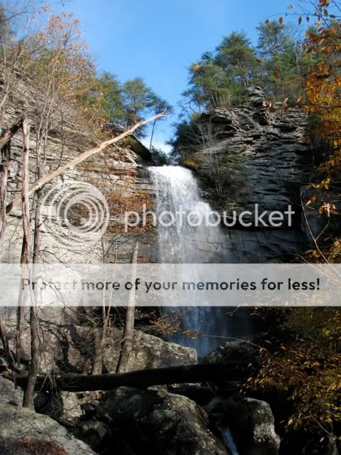
From the 80-foot descent of Laurel Falls until it joins Richland Creek, Laurel Creek tumbles through boulders and across exposed layers of rock laid down when the plateau was a seabed. Mostly sandstone, the rocks sometimes include nuggets of quartz and pebbles. At the junction of the two creeks is a broad boulder field and a few campsites for backpackers. The land was once owned by paper manufacturer Bowater but was given to the state a few years ago and is now part of Cumberland Trail State Park.
For more photos, visit my album on Facebook.
No comments:
Post a Comment